
The list of barely imaginable sights that Yellowstone National Park boasts is perhaps deserving of its own post.
Old Faithful has spewed water some 140 feet in the air every hour or so for thousands of years, the figurehead of the park’s vast thermal activity earning worldwide homage from multiple outlets, including the esteemed Looney Tunes and the inimitable Yogi Bear Show. Mammoth Hot Springs and the Grand Prismatic Spring have similarly given the park a reputation of being one of the most active geological areas on the planet.
The wildlife speaks for itself, with bison, elk, both black and grizzly bears, wolves, coyotes, moose, fox, and some 58 other species of mammals calling the park home, alongside numerous species of trout, eagles, and more.
It has perhaps the nation’s second most famous cascade, too, as the Yellowstone River tumbles over both the Upper and Lower Falls before entering the vast Grand Canyon of the Yellowstone.

You can drive your car into the park, to Old Faithful and the geyser field surrounding it, to the prismatic springs, and to the canyon falls overlooks. If you drive the some 450 miles of roads within park boundaries to see these features, odds are you’re going to see a good bit of that wildlife I mentioned, too – although the hoards of cars also out there to see them might scare them away before you get your own chance.
What is so often overlooked about Yellowstone’s 2.2 million acres is the beauty of its backcountry – not just that it’s undeveloped land on which all that wildlife can live and flourish, but that there are aspects of it that may well be worthy of their own National Park Service designations were they not already contained within the larger Yellowstone.
Yes, folks – believe it or not, some of the most amazing things you can see within the park don’t have roads that lead you anywhere near them. You’ll have to lace up your shoes and get there on foot, and the Bechler River (and Bechler Canyon) in the park’s southwest corner deserve your visit.
The Bechler River
Some 6-7 miles southwest of Shoshone Lake, the largest lake in the continental 48 states that has zero road access, sees the confluence of Phillips Fork, Gregg Fork, and Ferris Fork. Phillips and Gregg flow off Trischman Knob and the Madison Plateau to the north, while Ferris flows off the vast Pitchstone Plateau to the south.
Said confluence serves as the headwaters for the Bechler River, a drainage that carves deep through its namesake canyon for a powerful 20 or so miles before its own confluence with Falls River (or Fall River, as it’s commonly called now). The two serve as co-principle waterways of the Cascade Corner of Yellowstone, a name bestowed due to the myriad waterfalls that crash and splash their way towards the Idaho/Wyoming border.
The Routes
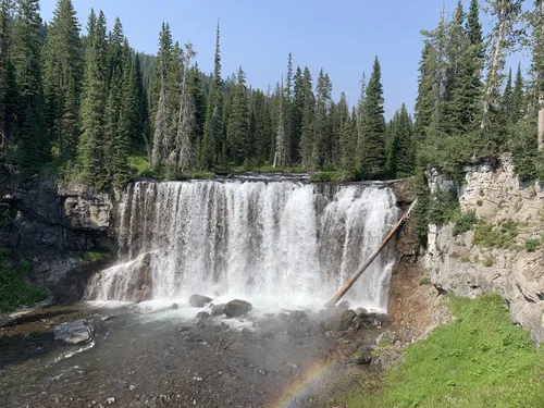
If you stick merely to the Bechler River Trail – which is accessible from the north via trailhead near the Old Faithful Visitor Center or from the east at Shoshone/Dogshead Trailhead north of Lewis Lake – you’ll encounter at least the Bechler River Cascades, Ragged Falls, Iris Falls, and the towering Colonnade Falls (the waterfall in this post’s header), the latter of which drops over 100 feet in a double-fall drop.
Most every guided tour of the area sticks to a ~30ish mile point to point route, with most accessing Bechler Canyon via Old Faithful and wrapping the trip at the Bechler Ranger Station. That’s because guided trips usually have the wherewithal to coordinate dropoff and pickup points, so you aren’t dealing with getting back to your car at a far-off trailhead on your own. Though remote, both the ranger station and nearby Cave Falls Trailhead are accessible via Idaho’s Cave Falls Road (outside national park boundaries), and therefore can be used as drop points for a second vehicle or, if you’ve contracted with a guide, likely an old schoolbus driven by a smiley fella with a big grey beard who’s eager as can be to get you back to your vehicle.
If you wanted to see just the Bechler Canyon and return as an out and back trip from Old Faithful, you’d be looking at roughly a 40 mile round trip. That would include some 15 designated backcountry campsites on-route, giving you a wealth of options to choose from while planning (and booking) your route through Recreation.gov. Since this route follows the Firehole River at the start and the Bechler for the bulk, access to water is about as straightforward as it gets this way.
Similarly, you can take the longer ‘entry route’ to the Bechler River Trail by entering from the Shoshone/Dogshead Trailhead further east, which crosses the Lewis River and skirts the southside of Shoshone Lake. Whereas reaching the start of the Bechler River Trail from Old Faithful takes roughly 5.7 miles each way (or 11.4 miles of the ~40 mile out and back round trip), heading in from Shoshone/Dogshead takes roughly 14.1 miles each way (or 28.2 miles round trip). That said, there’s a particular off-trail route that takes you up Cold Mountain Creek as it drains out of the southwest corner of Shoshone Lake, and following that drainage until it connects with the Bechler River Trail could shave off as much as 6 miles each way (or nearly 12 miles round trip).
Given the lack or true elevation gain or loss in this section of the park, these out and back options can feasibly be knocked out in either 5 reasonably-paced days or 4 more aggressively-paced days, if you’re going round-trip. If you’re merely going point to point, well, you could shave that down to 3 reasonably-paced days or a pair of speedy ones.
That said, if you’ve got the time and ability to plan a lengthier route through the Cascade Corner, the ability to see both Dunanda Falls and Union Falls joins the discussion.

Located just 0.6 miles from where the Bechler River Trail meets the Bechler Meadows Trail south of the canyon itself, the Bechler Meadows Cutoff Trail veers north towards the Boundary Creek Trail. Roughly 3.5 miles from when you peel off north from your main route sits Dunanda Falls, a roughly 110 foot cascade where Boundary Creek hucks and prays.
If you simply follow the Bechler River Trail south from the canyon until it intersects with the Mountain Ash Creek Trail, taking it east for roughly 6 miles will get you to the Union Falls Patrol Cabin, and nearly 2 miles further up the canyon from the Patrol Cabin lies Union Falls itself. At some 250 feet, it’s the second tallest waterfall in the entire park, and truly one of the best combinations of being unique and remote the park has to offer.

Tacking on days to pursue these additional features in Yellowstone’s Cascade Corner adds ample distance and time needed, but it also opens up exit points like the Fish Lake Trailhead, Cascade Creek Trailhead, Grassy Lake Trailhead, and Beula Lake Trailhead, all of which lie at the national park’s southern border with the Targhee National Forest. Each trailhead is accessible by vehicle (through varying road conditions), so you could drop a second car at each location if your party has access to such.
Given the sheer size of the Pitchstone Plateau and the dearth of established trails across it, there’s pretty much one way, and one way only to even begin to attempt the Cascade Corner as a loop where you never once retrace your steps on-trail. Even then, following the lonely Pitchstone Plateau Trail from its intersection with the Mountain Ash Creek Trail at the southern border of the park all the way to its terminus at the Phantom/Pitchstone Trailhead on South Entrance Road leaves you roughly 6 miles south of the Shoshone/Dogshead Trailhead, should you have chosen to enter the Bechler from that point. That means either walking the road or hitchhiking north to where you parked your car, and that’s with the 16.6 miles on the Pitchstone Plateau Trail under your belt.
For the record, an all on-trail ‘loop’ from Shoshone/Dogshead Trailhead through the Bechler Canyon, back out the Pitchstone Plateau Trail, and up the South Entrance Road stands at somewhere in the vicinty of 68 to 70 miles in total. Add-in another 8-8.5 miles for the round-trip detour to see Dunanda Falls, and you’re looking at a nearly 75 mile journey through one of the more remote, underhyped gems of the Greater Yellowstone Ecosystem. In theory, it could be accomplished in 7 days (6 nights), with a whole lot of wet feet and waterfall showers on the agenda.
If You Go…
- The southwest corner of Yellowstone National Park is its wettest region, not just because of the amount of water outflow it has in its rivers and creeks. It rains there early and often, and as a result the mosquitos are notorious for being thick there early and mid-season. While waiting later in the season brings in its own risks – drought, wildfire, and early-fall snow – waiting until late August to attempt routes within this area might save you your skin (literally).
- For my money, the best map of this area of Yellowstone is the Old Faithful/Yellowstone National Park SW one produced by Trails Illustrated (#302).
- Every route mentioned within this piece is entirely within Yellowstone National Park boundaries. That means that backcountry access is granted through a permit process only, and all camping must be done at designated backcountry campsites. Here’s my guide to navigate the early access lottery process and score the ability to book a trip in the area, as well as my follow-up guide on which routes (and campsites) to pick along the way.
- Plan at your own risk. Even the most straightforward on-trail day hikes in Yellowstone can involve varying terrain, changing weather, and off conditions. Every additional variable added to the most basic of hikes – overnight camping, food storage, unpredictable wildlife, water conditions, etc. – ony serves to augment the risk. Always check with Yellowstone backcountry rangers for updated conditions before beginning any trip, and I’d advise you to consult with them before booking one, too.
Discover more from Lit Wick
Subscribe to get the latest posts sent to your email.
Never seen a creek huck and pray, but would like to
Those creeks know how to send it!