
So you got your application to hike in the backcountry of Yellowstone National Park submitted into the lottery on March 1st, and you got lucky. You have scored an opportunity to book a route through the park’s 2.2 million pristine acres through Recreation.gov at the precise window given to you by the park service, you lucky little human, you!
Thing is, with 2.2 million remote acres come a myriad of variables. There are some 1,000 rivers and streams within the park that line up to over 2,500 miles of flowing water around the already gargantuan amount of freshwater lakes. There are geysers mud pots, hot springs both beautiful and deadly, and we haven’t even gotten to the bears just yet.
With some 293 backcountry campsites available throughout the year, even the variables have variables. Simply planning ‘a trip down the Lamar’ or ‘through the Thorofare’ can end up with wildly different experiences based on when, why, and where you camp. That’s why I’ve put together a step by step checklist to consider while planning your route that serves as a baseline guide regardless of which part of the park you’re planning to go see.


The Calendar
The bulk of Yellowstone sits around 8,000 feet above sea level, and mountains like Eagle Peak and Electic Peak soar to 11,000 feet. There’s a reason such ski resorts as Jackson Hole and Grand Targhee set up shop in the vicinity – it snows there, and it snows there a lot.
When you hit the early access lottery, you’re given a window to book trips anywhere between May 15th and October 31st, and there’s not a day within that window when snow falling on your head would be completely out of the question. That said, the extremities of that window sure do increase the likelihood, and that must factor into your decision.
Looking at the calendar is much more than merely trying to gauge whether you’ll get snowed on, or get cold. With an average annual snowfall of 150 inches (with higher elevations often getting more than 400 inches), it could be a sunny, 75 degree day in June when you’re facing the need to cross a snowfield on your trek. How much snow the winter doled out to Yellowstone, how deep the snowpack is, and how much snow has melted (or not) dictates not just whether you’re walking on snow, or not, but a plethora of other important factors.
How fast are the rivers running with all that snowmelt?
Melt season means mud and puddle season, and mud and puddle season mean bug season – is my campsite in a low-lying area that may be a bog?
It was a light year of snow in the Tetons and Absarokas – will that little stream on the map next to the campsite I chose still have running water in September?
The all-important inverse of knowing how snow impacts the calendar and your window to explore the backcountry is being very, very aware of what happens to Yellowstone when the snow’s all gone – namely, what happens when it becomes fire season. The earlier the snow melts, the longer the period the park goes between having last year’s snow and expecting new snow, and the drier everything there becomes. With summer thunderstorms – Electric Peak got its name for a reason – the odds of late-summer and early fall becoming a fiery situation increase, and that must be a consideration you make for booking any trip in August. You may dodge the mud and the bugs, yes, but you may be booking a trip that ends up smoked out (or ends up coinciding with a fire ban within park boundaries).
Snow and fire may seem like the two most important aspects of your calendar decision, and they probably are the two most vital. Still, there’s a final component to the calendar that I overlooked once in route planning years ago and it taught me a lesson I’ll never forget – sunlight.
The Farmer’s Almanac estimates that the sun won’t set in northwest Wyoming until roughly 8:43 PM on May 15th, with 14 hours and 47 minutes of sunlight at your disposal that day. On October 31st, however, it estimates that the sun will set at 6:16 PM with only 10 hours and 19 minutes of sunlight during the day – a difference of nearly 4 and a half hours. If you’re the kind of backpacker who covers 2.5 to 3 miles per hour, an extra 4.5 hours of sunlight can let you cover a whole lot more ground in a single day in May than in October, assuming you aren’t willing to hike at night on the same trails the bears and moose use. So, if you’re heading out in autumn and aren’t planning to hike at night, make sure you don’t overestimate your ability to cover the ground necessary to reach campsites that, in May, you’d get to with ease.


Campsite Nuance
If you’re out for just one night in late July, the weather is perfect, and you’ve got a short walk back to your car the next day, the number of considerations you’ll need to focus on in choosing your campsite might seem small. This is Yellowstone, though, and that scenario almost never presents itself.
All of its backcountry sites are remote. Even on the calmest, most clear-skied day, the chance of an evening storm is there. The winds will pick up, because that’s just what Yellowstone winds do. Therefore, aiming for as many sites that give you a natural advantage against the elements becomes more practical by the minute, especially if you’re on a trip that will spend five, six, seven nights in the wild.
There is no stock definition of what a ‘5-star campsite’ includes, but there are components of everyone’s definition that always end up the same.
- You’re going to want flat ground. Nothing kills the allure of an otherwise pretty site like getting into your tent and sliding to the other side in lieu of sleeping.
- You’re going to need water. Ideally, your site will sit far enough (150-200 feet) away from water so as to avoid flooding risk, too many bugs, or the risk of having thirsty animals in your camp, but also close enough that you have easy access to water for drinking and cooking while in camp.
- Live trees are your friend. Natural barriers to serve as wind breaks, they’ll also cast shade on your ideal site to get you cooled off quicker on hot days. That said, always be wary of sites that have lots of dead trees that have not yet fallen – especially since you’ll no doubt have noticed how much downfall of old pine trees there is in Yellowstone while on your hike.
- Privacy is what you’re out there for in the first place, right? Most people aim for sites that either a) aren’t large enough to accommodate multiple groups or b) aren’t right next door to another site. Seclusion means additional quiet, and also gives you a better chance of that elk or buffalo grazing in the field beside you.
- Speaking of why you’re out in the Yellowstone backcountry, you’re there for incredible views, right? For a site to truly be 5-star, I think it needs to have something worth staring at, be it a river valley, bend in a stream, craggy peak, or a meadow that looks exactly like where a bear would be. Camping surrounded by trees is nice, but you can do that anywhere.
- On-site luxuries can put otherwise comparable sites over the top. For instance, a decent number of sites within the park have bear boxes on-site, meaning you’ve got much easier access to your food and to storage than those that merely have a bear pole up in the trees. In addition, there are a handful of backcountry sites where fires are not allowed under any circumstances, and that can be a dealbreaker to many for aesthetic reasons while camping – or an out and out problem. If you’re out in October, it’s dark at 6 PM, you crossed rivers to get to your site and have wet clothes, and it’s going to dip into the teens that night, you’re going to be a little more peeved with yourself than normal if you’ve got yourself booked at a fireless site.
- Finally, you’re ideally aiming for high ground. That’ll alleviate any of the previously mentioned flooding concerns, but it also helps keep you warmer. Cold air falls and will pool in low-lying areas at night, often making them 10+ degrees colder than higher ground right next door.

Resources
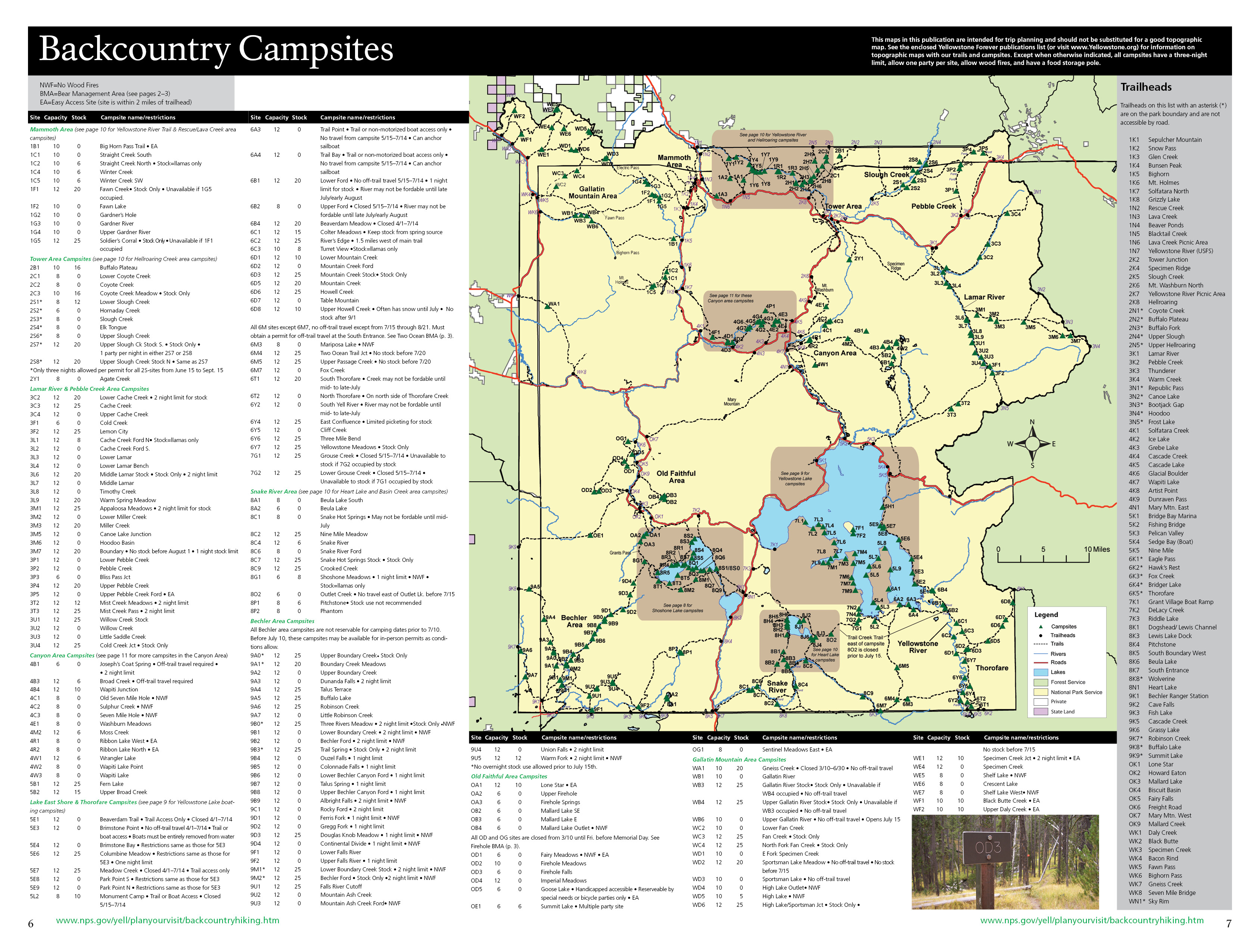
The park service does provide an excellent, interactive map of Yellowstone’s backcountry sites at NPS.gov. It lets you know the site’s capacity, whether or not fires are allowed, whether there’s a pit toilet there (or if you’re going to need a shovel and some thigh strength), and whether or not there’s a bear box on site.
What NPS.gov’s interactive site doesn’t provide for you, though, is how far away those sites are from where you started, or how far you’ll be travelling the next day to get to your next site. For that, you’ll need a quality map, and I’ve always leaned on those provided by Trails Illustrated. Their 4-pack of Yellowstone maps covers each of the quadrants of the park, giving you mostly accurate distances between stops on backcountry trails while adding topographic features to help you factor in how much up/down you’ll face each day (and, if you’re good at reading them, what kind of features you’ll be able to see from each campsite).

NPS.gov’s interactive map tells you what’s at the camp, and the Trails Illustrated maps will tell you all you need to know about how to get to each site. That Campsite Nuance section I just wrote, though, had a whole lot more parts to it, didn’t it? For better insight on which sites have a little bit more panache, quality guidebooks like that from Falcon Guides and author Bill Schneider become paramount. Two sites might be right next to one another with the same glorious view, but the prevailing winds might pummel the site on the wrong side of the tree grove while the other sits comfortably behind the break!
Finally, always check, double-check, and triple-check the backcountry regulations listed on NPS.gov, and make sure you’re prepped and ready to live up to them while in Yellowstone.
Discover more from Lit Wick
Subscribe to get the latest posts sent to your email.
Indeed, a myriad of variables
A plethora of piñatas